

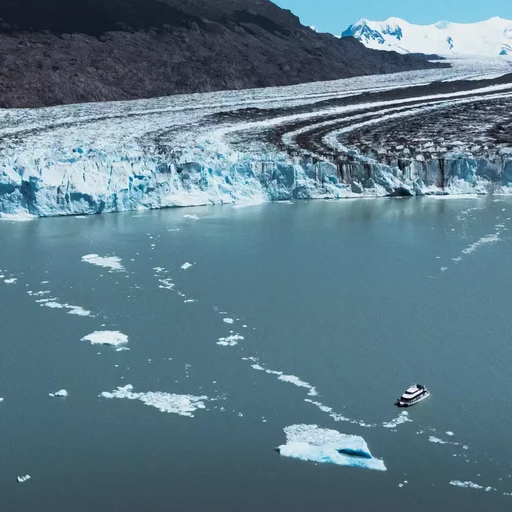
The retreat of the Upsala Glacier is one of the most pronounced in Patagonia: its terminus has moved kilometers backward in recent decades. This is influenced by climate warming and, above all, by the fact that it terminates in the deep waters of Lake Argentino, where iceberg calving accelerates ice loss. We have been navigating the North Arm of the lake since 1980, and the Upsala is the glacier that has changed the most before our very eyes.
To understand what's happening with the Upsala River, we need to look at two things simultaneously: the climate that feeds it and the lake where it ends. This article organizes what is known, without exaggeration or minimization.
A giant of 765 km²
The Upsala Glacier covers approximately 765 km², an area larger than the city of Buenos Aires, and is one of the largest glaciers in South America. It originates in the Southern Patagonian Ice Field, the vast continental ice mass that Los Glaciares National Park shares with Chile, and flows eastward until its terminus empties into the northern arm of Lake Argentino.
A glacier like this functions like an ice bank account. At the top, the snow that falls and doesn't melt compacts and turns into ice: that's accumulation. At the bottom, the ice melts or breaks off in the form of icebergs: that's ablation. If more ice is lost than gained over several years, the glacier front retreats.
Why is the Upsala Glacier retreating so rapidly?
The retreat of the Upsala Glacier cannot be explained by a single cause. Glaciologists typically point to three contributing factors:
- The weather. Higher temperatures in the melt zone and changes in snowfall on the ice field reduce the glacier's balance.
- Deep water. The Upsala is a calving glacier: it terminates in the lake. When the terminus rests on a deep bed, the water erodes the base of the ice, and calving events become more frequent and larger.
- The shape of the valley. If the riverbed where the glacier is advancing gets deeper towards the back, each retreat leaves even deeper water at the front. It's a self-reinforcing mechanism that can continue even if the climate stabilizes for a while.
Therefore, neighboring glaciers that originate from the same ice field can behave very differently. Climate is the backdrop; the geometry of each glacier determines the pace.
What changed in the landscape of the North Arm
Anyone who sailed the North Arm decades ago and returns today notices the difference. The Upsala front is farther away than before, and the area it left exposed has become open water, often dotted with icebergs. The slopes once covered by ice are now visible, washed and gray, bearing the marks left by a glacier scraping the rock.
This retreat also explains why the North Arm is the main route for icebergs from the lake. Each block that breaks off from the front floats and is pushed by the wind through the channel. If you're interested in this journey, we describe it in detail in "The North Arm of Lake Argentino, the route of icebergs to the Upsala ."
| Signal | Which indicates |
|---|---|
| Light-colored rock slopes with no vegetation at the front | Terrain that until recently was covered in ice |
| Many icebergs in the channel | Active landslides at the front |
| Horizontal lines on the valley walls | Levels that ice reached in the past |
| Milky turquoise water | Fine sediment that the glacier grinds and delivers to the lake |
What does Upsala tell us about the climate
Glaciers are slow thermometers. They don't react to a hot summer or an isolated snowy winter, but rather to trends that develop over many years. That's why the sustained retreat of the Upsala Glacier, like that of most glaciers in the Patagonian Andes, is taken as a clear sign of the warming of recent decades.
At the same time, the Upsala River teaches us not to oversimplify. Its rate of retreat is amplified by the deep lake where it ends, so it shouldn't be used as a direct measure of climate. It's more accurate to say that warming set in motion a process that the shape of the valley and the depth of the water accelerate.
The ice that is lost doesn't disappear: it ends up in Lake Argentino and, from there, continues its journey to the Atlantic Ocean via the Santa Cruz River. The Southern Patagonian Ice Field is the third largest freshwater reserve on the planet, and what happens to its glaciers matters far beyond Patagonia. We explain this in our article about the Southern Patagonian Ice Field.
How to see the Upsala Glacier today
The Upsala Glacier is explored by water. The All Glaciers Navigation departs from Puerto Punta Bandera, 47 km from El Calafate, crosses the Boca del Diablo (Devil's Mouth), and enters the North Arm among the Upsala icebergs before reaching the glacier itself. It then continues towards the Dry Glacier, the Heim Glacier, the Peineta Glacier, and the Spegazzini Glacier, with a stop at Spegazzini Base.
On board, the guide explains the dynamics of the glacier as the boat sails, and on land, the trails at Spegazzini Base have interpretive stations dedicated to glaciology. The boat trip takes 7 hours, and the total journey time is about 10 hours if you include the transfer from El Calafate.
A practical tip: the Upsala Channel is often windy. Bring a windproof jacket, hat, and gloves, and head out onto the outer decks during the iceberg sections, which is where you can best appreciate the scale of the glacier.
Watch Uppsala now
Glaciers change, and the Upsala Glacier is changing right before your eyes. Seeing it with your own eyes and hearing it explained by someone who navigates those waters every day helps you understand the climate better than any chart. Check availability and current rates on the All Glaciers Navigation website and add the Upsala Glacier to your trip.
FAQ
How far did the Upsala Glacier retreat?
Its front has retreated several kilometers in recent decades and is among the glaciers with the greatest retreat in Patagonia. The exact figure varies depending on the period and the source of the measurement.
Why is the Upsala Glacier retreating more than other glaciers?
Because in addition to climate warming, it ends up in the deep waters of Lake Argentino. The water erodes the base of the ice and accelerates calving, and if the valley deepens further back, the retreat is amplified.
Is it possible to see the Upsala Glacier on a tour?
Yes. The All Glaciers Navigation, which departs from Puerto Punta Bandera 47 km from El Calafate, travels along the North Arm among the icebergs of the Upsala to the viewpoint of the glacier.
What is the size of the Upsala Glacier?
It covers about 765 km², an area larger than that of the City of Buenos Aires, and is one of the most extensive glaciers in South America.

