

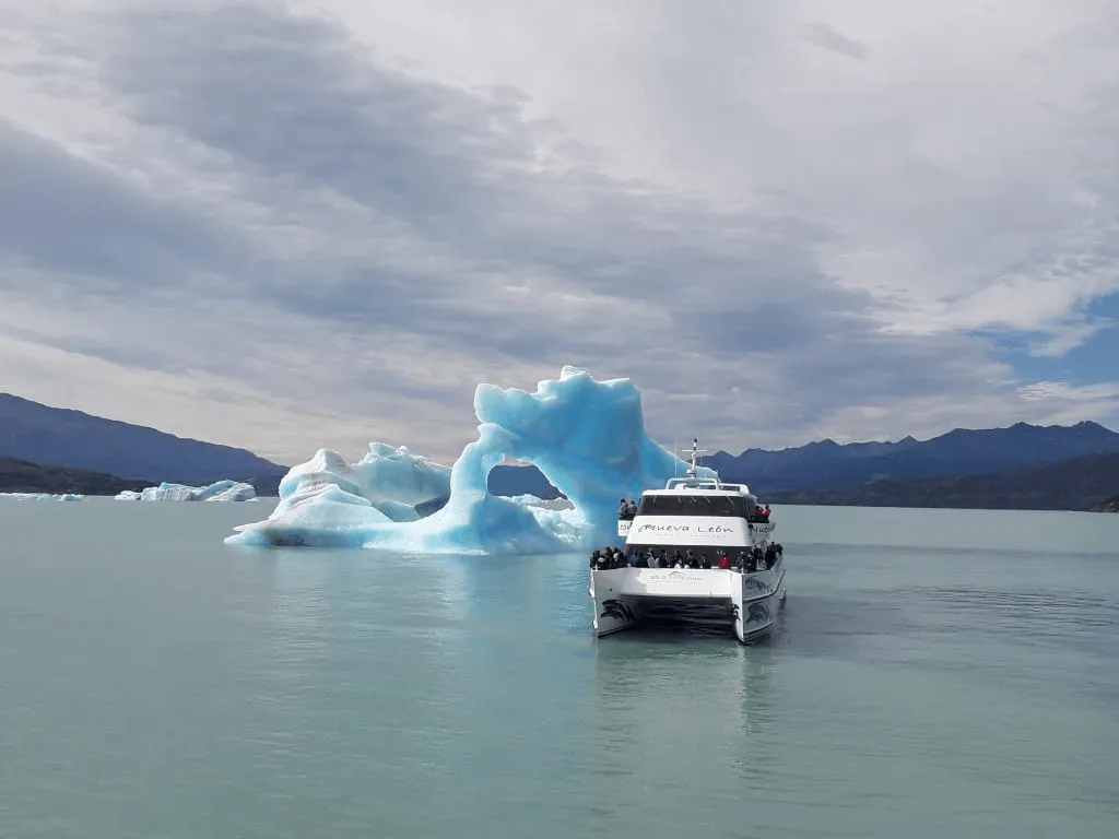
The North Arm of Lake Argentino is the long channel that opens beyond the Devil's Mouth and leads to the Upsala Glacier. It's the main route for the lake's icebergs: the ice that calves from the Upsala floats down the channel, and the boat navigates among these blocks before reaching the glacier. We've been traveling this route since 1980, and no two trips are ever the same.
If there's one stretch of the All Glaciers Navigation that defines the day, it's this one. We'll tell you what it is, why it's covered in ice, and how to enjoy it.
What is the North Arm of Lake Argentino?
Lake Argentino has a wide main body in front of El Calafate and long arms that extend westward between mountains. The North Arm is one of these: a deep, flooded glacial valley surrounded by steep slopes, connecting the open lake to the front of the Upsala Glacier.
The entrance is marked by the Devil's Mouth, a natural strait where the shores converge and the lake narrows. Passing through this strait signals the beginning of a different landscape. We describe it in detail in our article about the Devil's Mouth.
Why is the North Arm filling up with icebergs?
The Upsala Glacier, covering approximately 765 km², is one of the largest glaciers in South America and terminates in the lake. Its terminus is constantly calving: blocks of all sizes fall into the water and begin to float.
- The origin. Almost all the icebergs in the North Arm come from Upsala.
- Wind. The prevailing westerly wind pushes them away from the front, down the channel.
- The shape of the channel. Because it is a closed arm, the ice is contained and accumulates in certain areas until it melts.
- The setback. The retreat of the Upsala River in recent decades is closely linked to these landslides. We explain this in the note on the retreat of the Upsala Glacier.
That's why the number and position of the icebergs are constantly changing. Some days the channel is littered with loose blocks, and other days large masses of ice appear floating together.
How to navigate between icebergs
Navigating through floating ice requires skill. Icebergs are unstable: as they melt unevenly, they can capsize or break apart without warning, and most of their volume is submerged. That's why our captains always maintain a safe distance and choose their route based on the channel's conditions that day.
Our fleet of aluminum catamarans is designed for these waters. They have enclosed cabins, and the exterior decks allow you to go out and photograph the icebergs without losing sight of the scenery.
How to read an iceberg
| What you see | Meaning |
|---|---|
| White iceberg | Ice with a lot of trapped air, which scatters all the light |
| Deep blue iceberg | Very compact ice, with little air, that absorbs red and returns blue |
| Dark stripes | Sediment and rock that the glacier dragged |
| Smooth, rounded surface | An iceberg that flipped over and shows the side that was submerged |
| Sharp, angular shapes | A block that recently broke off, still uneroded |
The Upsala and the Dry Glacier
At the end of the iceberg route appears the Upsala Glacier. Seeing where all that ice that accompanied the ship came from concludes the North Arm tour. Afterward, the journey continues toward the Dry Glacier, a hanging glacier that doesn't reach the water, and then toward the Heim, Peineta, and Spegazzini glaciers, with a stop at Spegazzini Base. If you're curious about how a glacier can remain suspended on the mountain, we explain it in the article about the Dry Glacier.
Tips for the iceberg section
- Put on a warm coat before going on deck. The wind is stronger in the canal; windbreaker, hat and gloves.
- Look at the water too. Many small blocks pass close to the ship and show the blues better than the large ones.
- Use scale references. With nothing else nearby, an iceberg can be deceiving. If the photo shows the coast or a hillside, its size becomes clear.
- Listen to the guide. On board, they explain which glacier the ice comes from and why it has that color.
Sail the North Arm of Lake Argentino
The North Arm of Lake Argentino is part of the All Glaciers Navigation tour , which departs from Puerto Punta Bandera, 47 km from El Calafate, and lasts 7 hours, approximately 10 hours total including the transfer. There are daily departures from September to April and every other day from May to August. Check availability and current rates on the tour's website.
FAQ
What is the North Arm of Lake Argentino?
It is one of the arms of Lake Argentino that extend westward between mountains. It begins after the Boca del Diablo (Devil's Mouth) and leads towards the face of the Upsala Glacier.
Why are there so many icebergs in the North Arm?
Because the Upsala Glacier terminates in the lake and is constantly calving. The west wind pushes these blocks down the channel, and since it's a closed arm, the ice accumulates until it melts.
Is it dangerous to navigate among icebergs?
Icebergs can flip or break apart without warning, so captains always maintain a safe distance and choose their route according to the condition of the channel that day.
Which excursion covers the North Arm of Lake Argentino?
The All Glaciers Navigation, which departs from Puerto Punta Bandera, 47 km from El Calafate, crosses the Devil's Mouth and sails the North Arm among the icebergs of Upsala.


